NCERT Solutions for Chapter 8 Mapping Your Way Class 5 Maths

Chapter Name | Mapping Your Way NCERT Solutions |
Class | CBSE Class 5 |
Textbook Name | Maths |
Related Readings |
|
Page No 114:

(1) If you are walking on Rajpath then after India Gate on which side would Children's Park be?
(2) Which of these roads make the biggest angle between them?
(a) Man Singh Road and Shahjahan Road
(b) Ashoka Road and Man Singh Road (the angle away from India Gate)
(c) Janpath and Rajpath
(3) Which of the above pairs of roads cut at right angles?
Answer:
Yes, I have seen this shape before. It is a hexagon. It has 6 sides.
(1) The children's park would be on the right side, when we cross the India Gate, while walking on Rajpath.
(2) Correct: (b) Ashoka Road and Man Singh Road make the biggest angle between them.
(3) Looking at the map, we find that Janpath and Rajpath cut at right angles.
Page No 115:
Question 1: The children look at this map to see the parade route.

(2) Look at the map carefully and find out:
(a) Which of these is the longest road?
- B.S. Zafar Marg
- Subhash Marg
- Tilak Marg
(b) If Rubia is coming from Jama Masjid to join the parade, guess
about how far she will have to walk.
(c) The total route of the parade is about how long?
- 3 km
- 16 km
- 25 km
- 8 km
Answer:
(1) The route of the parade has been traced below. The Rajpath and India Gate has been marked on the map.

(2)
(a) Subhash Marg is the longest road among them.
(b) We know that the route of the parade through Subhash Marg and the Jama Masjid is 1 cm away from the Subhash Marg on the map.
Here the scale is 2 cm = 1 km so, 1 cm = 0.5 km
We know that, I km = 1000 m so, 0.5 km = 500 m
Thus, Rubia will have to walk about 500 m to join the parade.
(c) Total distance of parade in the map is 16 cm. And we know that, 2 cm on map = 1 km Thus, 16 cm = 8 km
So, the total route of the parade will be about 8 km.
Page No 118:
Question 1: Find out from Map 4
(a) Which of these is nearer to river Yamuna? - the Diwan-e-Aam or the Diwan-e-Khaas?
(b) Between which two buildings is Aaram Gah?
(c) Which buildings do you pass while going from Rang Mahal to the Hammam?
(d) Which building on this map is farthest from Meena Bazar?
(e) About how far is Lahori Gate from Diwan-e-Khaas?
Answer:
(a) Diwan-e-Khaas is nearer to river Yamuna than Diwan-e-Aam.
(b) Aaram Gah is between Diwan-e-Khaas and Rang Mahal.
(c) We will pass through Aram Gah and Diwan-e-Khaas while going from Rang Mahal to Hammam.
(d) Hammam is farthest from Meena Bazar.
(e) The map distance of Lahori Gate from Diwan-e-Khaas is about 6 cm. We know, 1 cm = 100 m So, ground distance of Lahori Gate from Diwan- e-Khaas = 6 × 100 = 600 m
Page No 119:
Question 1:
The side of the square was made two times bigger. Does its area also become two times bigger?
Answer:
Suppose the original length of side of square is 1 cm. Now, area of square = side x side = 1 × 1 square cm = 1 square cm
When the side of square is made two times bigger, then the new length of the side of the square will be 2 cm Area of square = side x side = 2 × 2 square cm = 4 square cm
So, when the side of the square is made 2 times bigger, then its area becomes 4 times bigger than the original area.
Page No 120:
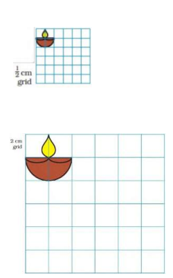
Question 1: This is a part of the parade-route Map 3.
(1) Can you see which part of the rout-map it is?
(2) Now try to make it bigger in this 2 cm grid. Remember that the 'shape' of the map should not change.
(3) If the parade route map is smaller, and the distance between India Gate and Vijay Chowk becomes 2 cm, what would be its scale?
- 1 cm on map = 1 km on ground
- 12 cm on map = 1 km on ground
- 2 cm on map = 1 km on ground
|
|
|
|
|
|
|
|
|
|
|
|
Answer:

(3) Originally, the distance between Vijay Chowk and India gate is 4 cm on the map. We are given the scale as 2 cm = 1 km. Thus, if the distance between two places becomes 2 cm, then the scale would be 1 cm on map = 1 km on ground
Page No 121:
Question 1:

(a) Towards west
(b) Towards east
(c) Towards south
(d) Towards north
(2) If I cm on the map shows 200 km on the ground, use this scale to find
out:
(A) About how far is Delhi from Jaipur?
(a) 50 km
(b) 500 km
(c) 250 km
(B) Estimate, how far is Jaipur from Bhopal? On the map = _______
- On the ground = _______ km.
(3) Look at the map and tell:
(a) Which state is surrounded by four other states?
(b) Which state has the largest area? If its name is not in the map, find it from your teacher or parents.
Explain how you got your answer.
(c) Which state is about 8 times bigger in area than Sikkim?
- Uttar Pradesh
- Tripura
- Maharashtra
- Himachal Pradesh
(d) About how many times of Punjab is the area of Rajasthan?
Answer:
(1) Correct:
(b) West Bengal is towards the east of Gujarat. Thus, Nonu will have to travel towards east to reach West Bengal, where his friend Javed lives.
(2)
(A) Correct:
(c) If we measure the map distance between Delhi and Jaipur with the help of a ruler, it comes out to be 1.2 cm. Here the scale is 1 cm = 200 km
So, 0.1 cm = 20 km Now, 1.2 cm = 1 cm + 0.1 cm + 0.1 cm Thus, ground distance between Delhi and Jaipur = 200 km +20 km + 20 km = 240 km
The ground distance between Delhi and Jaipur is about 250 km.
(B) If we measure the map distance between Bhopal and Jaipur with the help of a ruler, it comes out to be 2.4 cm. On the map = 2.4 cm. Here the scale is 1 cm = 200 km So, 0.1 cm = 20 km
Now, 2.4 cm = 1 cm + 1 cm + 0.1 cm + 0.1 cm + 0.1 cm + 0.1 cm
Thus, ground distance between Bhopal and Jaipur = 200 km +200 km + 20 km + 20 km + 20 km + 20 km = 480 km On the ground = 480 km.
(3)
(a) Himachal Pradesh is surrounded by four other states.
(b) Rajasthan has the largest area.
(c) The area of Himachal Pradesh is 8 times larger than that of Sikkim.
(d) The area of Rajasthan is 10 times larger than that of Punjab.
Page No 123:
Question 1: Bala is standing on the sea-coast and looking at the vast sea. The sea looks endless.

Have you seen the sea? In the picture where is the sea? Now look for the sea in the map of India. What colour is used to show the sea?
- Mark those states which have the sea on one side.
- Name one state which does not have the sea on any side.
Answer:
Yes, I have seen the sea. The sea is in front of Bala. The blue colour is used to show the sea on map.
The states which have sea on one side are: Gujarat, Maharashtra, Goa, Kerala, Tamil Nadu, Andhra Pradesh, Karnataka, West Bengal and Odisha.
The state which does not have sea on any side is Haryana.
Page No 124:
Question 1: Distances between Towns These are five towns. Find out:
(1) How many cm away is Idlipur from barfinagar on the map?
(2) How many kilometres will you have to travel if you go from Idlipur to Barfinagar?
(3) There is a place called Thukpagram midway between Idlipur and Barfinagar. Mark it with a 'T'.
(4) A town called Jalebipur is 35 kms away from both Chholaghat and Dhoklabad. Where do you think it can be? Mark 'J' for it.
(5) Measure the length of the route between Bhelpur and Chholaghat. (You can use a thread) Answer:
(1) The distance between Idlipur and Barfinagar on the map is 5 cm.
(2) Here, the scale is 1 cm = 10 km Distance between Idlipur and Barfinagar on the map = 5 cm Now, actual distance between Idlipur and Barfinagar = 5 x 10 = 50 km
Thus, we have to travel 50 km to go from Idlipur to Barfinagar.
(3) The place Thukpagram which is at the midway between Idlipur and Barfinagar is marked with T as shown below.

(4) Here the scale is 1 cm = 10 km So, 0.5 cm map distance = 5 km actual distance Actual distance of Jalebipur from Dhoklabad and Chholaghat = 35 km 10 km + 10 km + 10 km + 5 km
So, map distance of Jalebipur from Dhoklabad and Chholaghat = 1 cm + 1 cm + 1 cm + 0.5 cm = 3.5 cm
We can measure 3.5 cm and mark the town Jalebipur, with the help of thread as J on the map as shown below.

Thus, the length of route between Bhelpur and Chholaghat is 60 km.
Question 2: Ashi's school looks like this from the top. Use the squares to find out:

(1) How many times bigger is the area of the Assembly ground than that
of the office?
(2) How much is the length and width of each classroom?
(a) length 5 m, width 4 m
(b) length 2 m, width I m
(c) length 12 m, width 10 m
(d) length 5 m, width 5 m
Answer:
(1) The assembly ground covers 15 complete squares. Now, office covers 3 complete squares. Thus, we can say that area of the Assembly ground is five times the area of the office.
(2) Correct:
(a) Here, the scale is 2 cm = 5 m Length of each classroom = 5 m Width of each classroom = 4 m
Page No 125:
Question 1: All the classrooms in Ashi's school look like this.

(a) Which of these is exactly opposite to the blackboard?
- Almirah, windows, notice board, display board
(b) Now look at the school-map again. Guess and mark where would these be:
- Blackboard in III A and VII
- Almirah in IV and X
- Notice board in V and VI B
- Last seat of middle-row in II
- Display board in I.
(c) Can a child sitting in III A see the playground?
Answer:
(a) Display board is exactly opposite to the blackboard.
(b)
