
ICSE Revision Notes for Structure of the Earth Class 9 Geography

Chapter Name | Structure of the Earth |
Topics Covered |
|
Related Study |
Structure of the Earth
The Earth is made of several concentric layers. The outer layer of the Earth is known as the lithosphere. The interior of the Earth is divided into three layers—core, mantle and crust.
Crust (Lithosphere)
- It is the uppermost layer of the Earth and is a sphere of solid rocks.
- It is the thinnest of all the layers. It is about 35 km on the continental masses and only 5 km on the ocean floor.
- Two main mineral constituents of the continental mass are silica and alumina. Therefore, it is also called SIAL.
- The oceanic crust consists mainly of silica and alumina. Therefore, it is known as SIMA.


Mantle (Barysphere)
- This layer of the Earth lies underneath the crust. It extends up to a depth of 2,900 km below the Earth’s crust.
- The mantle is further divided into upper mantle and lower mantle. At the depth of 100–250 km, the mantle is in the semi-molten state and is known as asthenosphere.
Core
- It is the innermost layer of the Earth with a radius of about 3500 km. The boundary between the mantle and the core is known as Gutenberg Discontinuity.
- It is called NIFE (NI–nickel; FE–ferrous/iron) as it is made of nickel and iron.
- There is very high temperature and pressure in the Earth’s core.
Isostasy is a state of gravitational equilibrium between the lithosphere and the asthenosphere. There is a difference in the densities of continental and oceanic crusts. The continental crust lies above the ocean basin. It goes deeply into the asthenosphere than the ocean basin. However, both continents and ocean basins float on the asthenosphere which is in the semi-molten form. This state of balance is known as isostasy.
Formation of Landforms
A landform is a natural feature formed on the surface of the Earth. Landforms are formed because of the following reasons:
Plate Tectonics
- The lithosphere is broken into several small and big plates which float on the partially molten asthenosphere. These plates may collide or push each other.
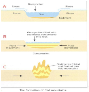
- Orogenic movements are responsible for the formation of the fold mountains.
- When the deposits of the sedimentary rocks lying between the two plates get compressed because of the movement of the tectonic plates, it results in folding of the rocks.
- Fold mountains such as the Himalayas and the Alps have been formed in this way.
Upliftment and Submergence
- When the vertical movements or the epeirogenic movements occurring inside the Earth along the radius from the Earth’s centre to the surface take place, it causes either the submergence or the upliftment of land.
- Such movements occur because of faulting. Block mountains, rift valleys and basins are formed as a result of faulting.
Sudden Forces
- Volcanic activities and earthquakes are described as sudden forces. Sudden forces are also known as ‘constructive forces’ as they form various relief features on the surface of the Earth.
- For example, volcanic mountains and plateaus are formed by volcanic activities and lakes may be formed as a result of earthquakes.
Exogenic Forces
- Folding and faulting are caused by endogenic movements (movements taking place under the surface of the Earth). Exogenic movements occur on the surface of the Earth.
- Rivers, glaciers and winds are the exogenic forces resulting in the creation of landforms by erosion and depositional activities.
- Exogenic forces are also known as ‘destructive forces’ as they cause widespread destruction of landforms through weathering and erosion.
Various Types of Landforms
There are five major types of landforms—mountains, plateaus, plains, valleys and basins.
Mountains
There are three types of mountains—fold mountains, block mountains and volcanic mountains.
Fold Mountains
- Fold mountains are caused by large-scale movements taking place inside the Earth’s crust. These movements are caused by various factors such as the movements in the mantle and the expansion and contraction of some parts of the Earth. These are horizontal movements.
- Fold mountains are formed when two tectonic plates move towards each other leading to the folding of the layers of the Earth. The up folds are called anticlines and the down folds are called synclines.
- Examples: Himalayas in Asia, Andes in South America, Alps in Europe

Chief characteristics of fold mountains:
- Fold mountains are some of the youngest mountains of the Earth.
- Most of the fold mountains are formed of sedimentary rocks. These sedimentary rocks were formed because of the deposition and collection of sediments in shallow oceans such as the Tethys (a hollow depression from where the Himalayas have emerged).
- Fold mountains are greater in length but comparatively smaller in width.
- Fold mountains are associated with volcanic activities as they have many active volcanoes.
- Many islands existing on the surface of the Earth such as the West Indies are the top surface of many fold mountains which exist under the seas.
Block Mountains
- Block mountains are formed because of faulting. Block mountains are formed when two tectonic plates move away from each other causing cracks on the surface of the Earth.
- When parallel cracks or faults occur, the strip of land or the block of land between them may be raised resulting in the formation of block mountains. The upward block is called a horst. Examples: Black forest and Vosges of Rhineland
- Block mountains are also formed when the crust of the Earth sinks on both sides of the two parallel faults. Therefore, a block mountain can be found between the two rift valleys. The land which sinks is known as graben. Example: East African rift valleys.


Volcanic Mountains
- Volcanic mountains are formed by volcanic eruptions. It occurs when molten rock or magma under the surface of the Earth erupts.
- Magma which flows out on the Earth’s surface is called lava. The accumulation of lava and its subsequent cooling results in the building of a volcanic mountain.
- Examples: Mount Kilimanjaro in Africa, Mount Fiji in Japan
Plateaus
An elevated flat piece of land is known as plateau. The upper part of the plateau is usually flat and is known as tableland. There are four main types of plateaus. These are
- Intermontane plateaus: Plateaus which are surrounded by hills and mountains from all sides are known as intermontane plateaus. Examples: Tibetan Plateau (highest plateau in the world), Columbian Plateau
- Piedmont Plateau: These plateaus are surrounded by mountain ranges on one side and plains on the other side. These are also called residual plateaus. Examples: Patagonian Plateau, Appalachian Plateau
- Volcanic Plateau: These are formed as a result of the flow of lava from volcanoes. Examples: Deccan Plateau, Ethiopian Plateau
- Uplifted Plateau: During volcanic activity, when the middle portion of the landmass gets elevated and has rounded sides, it is called an uplifted plateau. Examples: Chotanagpur Plateau, Ozark Plateau in USA
Plains
Plains are large pieces of flat land. They have a gentle undulating surface. There are three types of plains. These are
- Structural Plains: Plains which are formed because of the upliftment and submergence of lands are known as structural plains. Examples: Great Plains of USA, Coromandel Plains in India
- Erosional Plains: These plains are formed by the agents of erosion. They may be formed when hills are eroded and worn down. These are known as peneplains. Example: Niagara Plain in USA Many plains are also formed because of erosional activities of winds and glaciers.
- Depositional Plains: Plains formed because of the depositional activities of rivers and winds are known as depositional plains. The Great Indian Plains and the Mississippi Plains in USA have been formed by the depositional activities of the Ganga and Mississippi rivers, respectively. Plains such as the Thar Desert and the Sahara Desert have been formed by the deposition of wind. Many plains are also formed because of marine deposition. Example: East coast of India
Valleys and Basins
Valleys are formed because of both tectonic and erosional forces. The Rift Valley of East Africa has been formed by tectonic forces, while the Ganga Brahmaputra Valley is an example of a valley formed by erosional forces. A basin is formed because of the depositional activities of a river.
Importance of Landforms
- Landforms form the relief features of the Earth and influence the climatic conditions of the regions in which they are located; for example, the Himalayas influence the climate of northern India.
- Many snow-capped mountains are the sources of the perennial rivers.
- Slopes of mountains are covered with thick forests and thus maintain biodiversity on the Earth.
- Plateaus are the sources of various minerals.
- The lava plateaus formed by volcanic eruptions have black soil, which is suitable for cultivation.
- Many ancient civilisations developed on river banks. Plains have extremely fertile soil and support agricultural activities.
- Landforms such as mountains, valleys and plateaus have many scenic spots which greatly attract tourists.
Maps
Forces and movements arising from the interior of the Earth and causing horizontal and vertical movements are known as endogenic forces. The two kinds of endogenic forces are diastrophic and sudden movements. Volcanoes are caused by sudden movements occurring in the Earth’s interior.

