ICSE Revision Notes for Hydrosphere and Ocean Waves Class 9 Geography

Chapter Name | Hydrosphere and Ocean Waves |
Topics Covered |
|
Related Study |
Earth, the Watery Planet
The Earth is a unique planet as it has many conditions which make life possible on it. Life on Earth would not have been possible without the presence of water.
Distribution of Land and Water on the Earth
- While three-fourth surface of the Earth is covered with water, quarter of the Earth is land.
- Much more land exists in the Northern Hemisphere than in the Southern Hemisphere.
- The main landmasses generally taper towards the east.
- Isthmus of Panama joins North America with South America. Eurasia is joined to Africa by the Isthmus of Suez.
- In the North Pole, the Arctic Ocean is surrounded by the continents of North America and Eurasia. In the South Pole, Antarctica is covered with thick sheets of ice.
The Oceans
All oceans in the world are connected to each other. The main oceans on the Earth are
The Pacific Ocean
- It is the largest and the deepest ocean in the world. It is oval.
- It is bounded by North America and South America in the east and Asia and Australia in the west.
- The Pacific Ocean has a much shorter and regular coastline and has fewer harbours than the Atlantic Ocean.
- Because its shores are not bordered by very fertile and commercial lands, it is commercially less important than the Atlantic Ocean.
- The Mariana Trench, the deepest known point on the Earth’s surface, is located in the Pacific Ocean.
The Atlantic Ocean
- It is the second largest ocean in the world. It is an S-shaped ocean.
- The Central Ridge runs almost in the middle of the Ocean. It is on this ridge (a ridge is a geological feature which consists of a chain of mountains or hills running for a considerable distance) that most islands of the Atlantic Ocean lie.
- The coastline of the Atlantic Ocean is broken and is bordered by many fertile lands of Europe.
- The Atlantic Ocean is the biggest highway of commerce.
The Indian Ocean
- It is the third largest ocean in the world. It is the only ocean which is named after a country (India).
- It is surrounded by the Indian subcontinent in the north, East Africa on the west and Indo China in the east.
- Sunda Trench is the deepest point in the Indian Ocean.
- After the construction of the Suez Canal (connecting the Indian Ocean with the Mediterranean Sea), its commercial importance has increased.
The Arctic Ocean
- It is located near the North Pole and mostly remains frozen.
- It is connected to the Atlantic Ocean by the eastern and western Greenland channels and the Pacific Ocean by the Bering Strait.
- Many scientists contend that it cannot be regarded as an ocean as it is not navigable. This is because it freezes completely during winters. However, its separate existence and its area spreading over 13 million sq km entitle it to be called an ocean.
Many geographers regard the area around the Antarctica continent as the Antarctic Ocean, but most scientists are of the view that this portion of the Earth has no natural boundaries to the south. It consists of the southern portions of the Pacific, Atlantic and Indian oceans. It is thus also known as the Southern Sea.
Main Features of the Ocean Basin
An ocean basin is a depression in the surface of the Earth in which the ocean lies. Many trenches, ridges, canyons and plateaus exist in the ocean basin as a result of the tectonic, volcanic, erosional and depositional processes. Chief features of the ocean basin are
- Continental Shelf: It is the area of the sea bed which is adjacent to the coastline and is not as deep as the open ocean. The continental shelf is so shallow that even sunlight can reach the seabed.
- It is rich in oil, coal and non-ferrous metals. One can find many types of plankton here. This makes the continental shelf the richest fishing grounds.
- Continental Slope: The slope between the outer edge of the continental shelf and the deep ocean floor is known as the ocean slope. It occupies 8.5% of the total ocean area. The continental slope consists of light continental rocks which lie over the dense rocks of the ocean floor.
- Deep Ocean Floor: Ocean floors are situated on the base of the continental slope. The depth of the ocean floors varies from 3000 to 6000 metres. On the ocean basins, many plateaus, plains and volcanic summits may be found. About two-thirds of the ocean surface is occupied by deep ocean floors.
- The Ocean Deeps: Deep trenches are known as ocean deeps. Some ocean deeps are as deep as 36,000 feet. The deepest part in the ocean in the world is Mariana Trench which is about 11,033 metres deep. Its depth is more than the height of Mount Everest on the land. Another deep trench is the Tonga Trench with a depth which exceeds 10,000 metres.


Main Features of Oceans and Land
Some main features of oceans and land:
- Isthmus: An isthmus is a narrow stretch of land which connects two landmasses and separates two water bodies. For example, the Isthmus of Panama links North America with South America but separates the Pacific and Atlantic oceans.
- Gulf: A deep inlet of the sea almost surrounded by land with a narrow mouth is called a gulf. The Persian Gulf, the Gulf of Mexico and the Gulf of Alaska are some important gulfs.
- Strait: A strait is a narrow passage of water connecting two large water bodies. The Davis Strait connects Baffin Bay with the North Atlantic Ocean. The Bering Strait once connected Asia and North America. It is now filled with water and connects the Arctic Ocean with the Bering Sea.
- Island: A piece of land surrounded by water on all sides is known as an island. Greenland is the largest island in the world. An island may be formed because of tectonic activities such as folding, faulting and volcanic activities. In India, some islands of the Andaman and Nicobar Islands are of volcanic origin, while the Lakshadweep Islands are formed of corals. Islands near the sea shore have been formed by denudation of the land mass by sea waves.
Importance of Oceans
- Oceans are extremely important to human life. Following are the importance of oceans: ∙ Fish is an important source of food and nutrition to human life. It has been a vital part of the human diet since prehistoric times. Fishing has become a well-developed industry today and significantly contributes to the economy of many nations.
- Oceans provide food and other marine products to humans. Several kinds of edible oil are manufactured by humans from marine animals. Besides, food and oil, marine animals and plants also provide leather, glue and cattle feed.
- Much research is on to extract essential oil and other products of marine life which can cure different diseases. Marine pharmacologists are researching on the physical and chemical properties of marine organisms such as crab, sea cucumber, shark and cod.
- Oceans provide us with a variety of mineral resources. Some of these are common salt, magnesium, bromide, sulphur, gold, platinum, tin, sand and petroleum.
- The most important mineral resources obtained from the sea are petroleum and natural gas. Petroleum known as the ‘Black Gold’ is mainly found in the continental shelves and slopes. Bombay High is an important source of oil in India.
- Oceans also provide us with non-conventional sources of energy such as tidal energy—the energy generated from waves. The rise and fall of seawater is known as tides. Powerful tidal waves generate a large amount of force when they strike the shore. This energy is tapped and used to produce electricity.
- Many countries are researching on the prospects of harnessing energy from the surface of ocean waters. Water at the surface of the sea in tropical regions may reach up to 30°C. Belgium and Cuba have designed floating generators which can be used for the production of electricity.
- Oceans have been used as a means of transport since the ancient times. Water transport is one of the cheapest means of transport in the world.
- Oceans also regulate the temperature of the Earth. They cover about 71% of the Earth’s surface. They store the heat of the Sun and keep the Earth warm. This is because oceans absorb the heat of the Sun and release it after a long time. On the other hand, land gets heated and releases the heat quickly. Had the land been greater than the water, it would have remained frozen for most time of the year.
- Oceans play an important role in the water cycle. About 97% of the total water available on the Earth is stored in oceans. Water evaporates from the oceans in the atmosphere. It then condenses and precipitates on the Earth in the form of rainfall, dew and snow.
The importance of oceanic resources has created disputes regarding the control of oceans by various nations. Many nations claim their rights over sea waters located near their land. However, it is to be noticed that every country with a coastline has its own territorial waters and exclusive economic zone. The concept of the defence of oceans has acquired significance in the past few years.
It is important to keep oceans free of any pollution. Spilling of oil from oil tankers, dumping of radioactive wastes from ships and conducting of nuclear explosions in the sea need to be checked to preserve the rich marine life.
Map showings Oceans, Seas, Gulfs

Movement of Ocean Waters
Seawater is mobile. It moves horizontally and vertically. The movement of seawater takes place in three different ways—through waves, tides and currents.
Waves
Waves are the alternate rise and fall of the sea surface or seawater. The following is the structure of a wave:
- A wave has a curve-like structure. The top part of the wave is known as the crest.
- The lower part of the wave between two crest points is known as the trough.
- The distance between two consecutive crests and two consecutive troughs is known as the wavelength.
- Wave period is the time taken by two consecutive crests to pass any fixed point.
- The vertical distance between a trough and a crest is called the wave height.


Tides
The rise and fall of seawater because of the gravitational forces of the Sun and the Moon are called tides. Sea waves produced by tides are known as tidal waves. The rise of seawater and its movement towards the coast is called tide. As a result, when the water level is high, it is known as high water tide. The fall of seawater and its movement towards the sea is called ebb. The resultant low water level is called low tide water. The difference between high tide water and low tide water is called tide range.
Factors Causing Tides
Tides are caused by the following reasons:
- Tides are basically caused by the gravitational pull of the Moon and the Sun.
- The Earth revolves round the Sun and the Moon revolves around the Earth in an elliptical orbit. The distance between the Earth and the Moon changes many times during a month.
- The surface of the Earth which faces the Moon experiences maximum gravitational pull of the Moon. As a result, the water of the Earth’s surface gets pulled up and thus high tides occur.
- High tides also occur in the part of the Earth which is facing away from the Moon because of the centrifugal force (the force which draws a rotating body away from the centre of rotation) of the gravitational pull of the Moon causing an outward bulge of water.
- The period of farthest distance between the Moon and the Earth is called apogee. The period of the nearest distance between the Moon and the Earth is known as perigee.
Some Facts about Tides
- Tides and ebbs occur twice on the Earth’s water surface in 24 hours. High tides take place when the Sun, the Earth and the Moon are in the same line. When their gravitational forces work together, high tides are formed.
- When the Sun and the Moon are at the position of right angles with reference to the Earth, the gravitational forces of the Sun and the Moon work against each other resulting in low tides.
- Every place experiences tides twice a day.
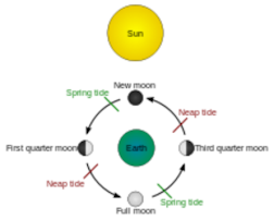
- When the Sun, Moon and Earth are in the same line, the tides are highest and they are called spring tides.
- When the Moon is in its first and last quarter, the ocean water gets pulled in the opposite direction of the Moon by the Sun’s and Earth’s gravitational force causing low tides. These tides are also known as neap tides.

Importance of Tides
- Tides can cause a change in the landforms of the Earth. While tides can destroy the coastlines, they also help in the formation of creeks and inlets.
- Strong tides help in building lower floodplains of rivers. These are very fertile.
- Because the debris is swept away by the tides, they help keep the harbours clean.
- In cold countries, tides bring in saltwater to the shore and their continuous movement prevent the harbour from becoming ice bound.
- The low-lying areas of the sea coast during high tides trap water which is used for the manufacturing of salt. Salt is manufactured along the west coast of India in this manner.
- The alternate rise and fall of tides help fisherman to sail out and return to the coast.
- Tidal energy is fast becoming an important source of non-convectional sources of energy. They are used in the production of electricity along the Gulf of Kachchh in Gujarat.
Ocean Currents
Ocean currents are the regular movements of water in the oceans. They move in a circular pattern around the oceans. Based on temperature and depth, ocean currents may be divided into the following divisions:
|
Based on temperature |
Warm currents and cold currents |
Warm currents: These currents flow from low latitudes in the tropical zone towards the high latitudes in the temperate and sub-polar regions. These currents bring warm water to cold regions. Cold currents: These currents flow from the polar regions to the equatorial regions. These currents bring cold water to warm regions. |
|
Based on depth |
Surface currents and deep water currents |
Surface currents: These currents make about 10% of all water in the ocean. Deep water currents: These currents make about 90% of all water in the ocean. |
Causes of Ocean Currents
Factors which affect ocean currents:
- Temperature: Temperature affects the origin and nature of ocean currents. As equatorial and tropical regions are warm, the oceans lying near the Equator and the tropics are warmer than the oceans lying near the Polar Regions. Thus, the ocean currents from warm equatorial regions move towards the Polar Regions as warm currents. Similarly, the cold currents move from the Polar Regions to the equatorial regions as cold currents.
- Level of Salinity: Oceans with a higher level of salinity are denser than oceans with lower levels of salinity. Generally, the ocean currents are generated from areas of less salinity to areas of high salinity.
- Because the Mediterranean Sea is more saline than the Atlantic Ocean, most ocean currents flow from the Atlantic Ocean to the Mediterranean Sea.
- Rotation of the Earth: The Earth rotates from west to east. The speed of rotation of the Earth is maximum at the Equator. All the moving bodies move in a clockwise direction in the Northern Hemisphere and in an anti-clockwise in the Southern Hemisphere. This is also known as the Coriolis Effect.
- Planetary Winds: Winds affect the ocean currents. The trade winds blow between the Equator and the Tropics. These winds thus move the equatorial water towards the poles. For example, the Southeast Trade Winds drift the equatorial current to the eastern coast of Australia as the warm East Australian Current.
- Landforms: A landform may influence the ocean currents. For example, the shape of various landmasses may obstruct the flow of water and influence its movement. For example, the South Equatorial Current gets deflected towards the Northern Hemisphere.
The circulation pattern of the ocean currents is influenced by the Earth’s atmospheric circulation pattern. At higher latitudes, the wind flow is cyclonic. Thus, the oceanic currents move in a cyclonic pattern. Similarly, in middle latitudes, air circulation is mainly anti-cyclonic. The currents thus move in an anti cyclonic pattern.
Major Ocean Currents
|
Name of Current |
Type of Current |
Origination |
Characteristics |
|
The Gulf Stream |
Warm Current |
Gulf of Mexico, the Atlantic Ocean |
It is a powerful warm current which keeps the climate of Western and Northern Europe warm. Its presence has led to the development of strong cyclones. It is also used as a source of power generation. |
|
The North Atlantic Drift |
Warm Current |
The Atlantic Ocean |
The Gulf Stream current gets deflected towards the east because of the Westerlies and the rotation of the Earth and reach Europe as the North Atlantic Drift. This current keeps the ports of Europe free of ice even during winters. |
|
The Kuroshio Current |
Warm Current |
The Atlantic Ocean |
It begins from the east coast of Taiwan and flow towards Japan. The warm waters of this current sustain the coral reefs in the world. |
|
The Labrador Current |
Cold Current |
The Atlantic Ocean |
It flows from the Arctic Ocean and meets the warm Gulf Stream in the southeast coast of Newfoundland. In early summers, this current transports icebergs from the glaciers of Greenland to the Trans-Atlantic shipping lanes. It has a cooling effect on the Canadian Atlantic provinces. |
|
The Oyashio Current |
Cold Current |
The Atlantic Ocean |
It impacts the climate of the Russian Far East. The waters of the current form the richest fishing grounds in the world because of high nutrient content of the cold waters. |
|
North Equatorial Current |
Warm Current |
The Pacific Ocean |
It flows from the western coast of Mexico to the Philippines. |
|
South Equatorial Current |
Warm Current |
The Pacific Ocean |
It flows in the southern Pacific Ocean and bifurcates into the northern and southern branches near New Guinea. |
|
California Current |
Cold Current |
The Pacific Ocean |
It flows along the western coast of USA and merges with the warm North Equatorial Current. |
|
West Wind Drift |
Cold Current |
The Pacific Ocean |
It flows from west to east in the zone of 40°S–50°S under the influence of the Westerlies. |
|
Peruvian |
Cold Current |
The Pacific Ocean |
It flows northwards along the western coast of South America. |
|
Indian Equatorial Current |
Warm Current |
The Indian Ocean |
It flows westwards in the South Indian Ocean. |
|
Southwest Monsoon Current |
Warm Current |
The Indian Ocean |
It flows along the coast of India in the easterly direction. |
|
Northeast Monsoon Current |
Warm Current |
The Indian Ocean |
It flows along the eastern coast of India during winters. |
Effects of Ocean Currents
- Affect Temperatures: Currents influence the climatic conditions of the regions in which they blow. The warm equatorial currents raise the temperature of the region in which they blow. Similarly, the cold currents lower the temperature of the places where they blow. For example, British Isles would have been extremely cold without the warm North Atlantic Drift. The hot climate of Peru is cooled by the cold Peru Current.
- Affect Rainfall: The winds blowing over warm currents pick up and carry moisture and bring rainfall. For example, the North Atlantic Drift brings rainfall in some areas located along the western coasts of Europe. On the contrary, cold currents do not bring rainfall and make the region cooler and drier. The Kalahari Desert hardly experiences rainfall because of the cold Benguela Current.
- Fog: The meeting of the warm and cool currents results in the creation of fog. For example, the Japanese coast experiences heavy fog when the warm Kuroshio current meets the cold Oyashio current.
- Violent Storms: At times, the meeting line of a warm and a cold current may cause a violent storm. The hurricanes which occur off the coast of USA follow the line where the Gulf Stream merges with the Labrador Current.
- The mixing of warm and cold currents results in the deposition of plankton. Therefore, at such places, fish can be found in abundance.
- Currents help the ships to sail if they follow the directions of the currents.
- Many warm currents keep the ports of Europe ice-free even during the winters. This helps in trade and commerce.
- The ships face danger because of the fogs caused by the meeting of the warm currents with the cold currents. This has resulted in the wreckage of many ships in the past as they were not able to view icebergs because of poor visibility.