
ICSE Revision Notes for Geographic Grid: Latitudes and Longitudes Class 9 Geography

Chapter Name | Geographic Grid: Latitudes and Longitudes |
Topics Covered |
|
Related Study |
The Earth’s Grid
Geographic Grid
A globe is a three-dimensional model of the Earth. It is used by navigators and geographers to locate places on the Earth. Students use it in schools for learning various features of the Earth. We draw latitudes and longitudes across the globe to locate places on it. Imaginary lines running east to west, parallel to the Equator, are known as lines of latitude. Imaginary lines running north to south, across the poles, are known as lines of longitude. The framework formed by the intersection of the latitudes and longitudes on the Earth is known as a geographic grid. It helps us to locate exact places on the globe.

Lines of Latitude
The lines of latitude form one of the coordinates of the grid system. A line of latitude represents the angular distance of a place located to the north or south of the Equator. The Equator is at 0° latitude. Lines of latitude are the imaginary lines joining all places having the same latitude towards north or south of the Equator. These are also called parallels of latitudes as they run parallel to the Equator. There are 181 parallels of latitudes.
Main Latitudes
- The Equator is the longest latitude.
- The North Pole is located at 90°N.
- The South Pole is located at 90°S.
- The Tropic of Cancer is located at 23 ½° N in the Northern Hemisphere.
- The Tropic of Capricorn is located at 23 ½° S in the Southern Hemisphere.
- The Arctic Circle is located at 66 ½° N of the Equator.
- The Antarctic Circle is located at 66 ½° S of the Equator.
Each latitude forms a full circle. The Equator is a great circle. The length of the circles decreases as we move towards the poles.
Northern and Southern Hemispheres
- The Equator divides the Earth into two equal parts. The part lying to the north of the Equator is known as the Northern Hemisphere and the part lying to the south of the Equator is known as the Southern Hemisphere.
- The North Pole (90°N) is located in the Northern Hemisphere at the extreme end of the Earth. The South Pole (90°S) is located to the south of the Equator in the Southern Hemisphere.
- The length of the Equator is equal to the circumference of the Earth which is 40,077 km. Because the Equator is a great circle and the circumference of a circle is equal to 360°, 1° angular distance is approximately equal to 111 km.
Latitudes help us to find the distance of any place from the Equator based on its degree of latitude. Example: Chennai is located at 13°N. Because 1° latitude = 111 km, the distance of Chennai from the Equator will be 13 × 111 = 1443 km.
Major Heat Zones of the Earth
Latitudes divide the Earth into three different heat zones. Because the Earth is spherical, different parts of the Earth get heated differently. Based on the heat received from the Sun, the Earth is divided into three heat zones. They are
Torrid Zone: It is a region between the Tropic of Cancer and the Tropic of Capricorn. This region receives the direct vertical rays of the Sun for almost the whole year. Therefore, this zone gets maximum heat from the Sun. This zone is known as the torrid or tropical zone.
Temperate Zone: This zone lies between the Tropic of Cancer and the Arctic Circle in the Northern Hemisphere and between the Tropic of Capricorn and the Antarctic Circle in the Southern Hemisphere. This zone gets the slanting rays of the Sun as the angle of the Sun’s rays goes on decreasing towards the poles. Thus, this zone experiences moderate temperature.

Frigid Zone: The Frigid Zone lies between the Arctic Circle and the North Pole and between the Antarctic Circle and the South Pole. This zone is also known as the polar region. Because it receives the extreme slanting rays of the Sun, the temperature is extremely low throughout the year. This is the reason the polar regions are generally covered with ice.
Lines of Longitude
Main characteristics of longitudes:
- The vertical lines which run from the North Pole to the South Pole are called longitudes or the meridians of longitudes.
- It is not possible to find the exact location of a place only on the basis of latitudes. We also have to take into account the longitudes.
- The distance between two longitudes is measured in terms of degrees. Longitudes are semi-circular and the distance between them decreases as they go towards the poles. The distance between two lines of longitude is maximum at the Equator (111 km). The two diametrically opposite lines which make a full circle is also known as a great circle.
- The Prime Meridian is a 0° longitude which passes through the British Royal Observatory at London. It divides the Earth into the Western Hemisphere and the Eastern Hemisphere.
- When the latitudes and longitudes criss-cross each other at right angles, they form a geographical grid or coordinate which helps us to find the exact location of a place.

Longitude and Time
- As the Earth completes one rotation from west to east in 24 hours, every meridian gets direct sunlight from the Sun once every day.
- The Earth has been divided into twenty-four time zones of one hour each. Each zone thus covers 15° of longitude. 1° of longitude is covered in 4 minutes.
- When the Greenwich meridian gets direct sunlight, the places located along it have mid-day. As the Earth rotates from west to east, the places which are located to the east of the Greenwich meridian are ahead of Greenwich time.
- In the same way, the places located to the west of Greenwich are behind Greenwich time. So, to find the local time of a place, for each 1° of longitude towards the east, 4 minutes are added and for each 1° of longitude towards the west, 4 minutes are subtracted.
Indian Standard Time
The local time of a place depends on the longitude which passes through it. Many longitudes pass through India. Therefore, the standard time for each country is usually taken as the time of the central meridian which passes through it. In India, 82 ½ °E longitude determines the standard time. This is known as Indian Standard Time. This longitude passes through Allahabad in Uttar Pradesh.
Calculating Time
- We can calculate the time of two different places with the help of their longitudes. Lucknow is located at 82° E and London is located at 0° GMT.
- Because the Earth rotates from west to east, places which lie to the east of Greenwich are ahead of places which lie to the west of Greenwich. The Earth rotates 1° in 4 minutes. Thus, if Lucknow is located in the east of Greenwich at 82°E, we will multiply 82 by 4 which will be 328 minutes or 5 hours and 28 minutes. Therefore, the time at Lucknow is 5 hours and 28 minutes ahead of London (since Lucknow is located to the east of Greenwich). So, if the time in London is 12:00 pm, we will add 5 hours and 28 minutes to it, which will be 5:28 in the evening. Therefore, it will be 5:28 pm at Lucknow in the evening when it is 12:00 pm in London.
International Date Line
The International Date Line is an imaginary line which runs across the surface of the Earth at 180° longitude. Because this longitude is diametrically opposite to that of the Greenwich meridian, it results in a difference of 24 hours on crossing the line.
To avoid the confusion of having different dates (difference of 24 hours results in the changing of date) in the same country, the International Date Line has been outlined according to international agreement. This is why the International Date Line bends and goes zigzag at the Bering Strait (between Siberia and Alaska), Fiji, Tonga and in some other islands.
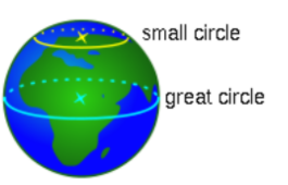
Great and Small Circles
A great circle is a circle which is drawn on the surface of the Earth in a way that the centre of the Earth also becomes the centre of the circle. Main characteristics of great circles:
- A great circle is the largest circle which can be drawn on the surface of the Earth.
- Many great circles can be drawn on the surface of the Earth.
- All great circles divide the Earth into two hemispheres.
- Intersecting great circles always bisect each other.
- The Equator is the only latitude which is a great circle.
The radius of the great circle is equal to the radius of the Earth. All the great circles divide the Earth into halves. All meridians of longitude are great circles.
Small circles are circles whose centre point is not the centre of the Earth. The radii of small circles are smaller than the radius of the Earth. All latitudes except the Equator are small circles.
Uses of Great Circles
- Great circles are important to us in the following ways:
- Great circles help in navigation and aviation.
- Navigators use great circles to find the shortest distance between two places on the Earth’s surface. ∙ Ships crossing the oceans and aircraft flying in the air follow the great circles to save time and fuel.
Limitations of Great Circles
Some limitations of great circles:
- Aeroplanes are not always able to follow great circles as some countries do not permit them to fly over their country zones.
- At times, great circles may not touch large cities from where the air traffic may originate.
